...Helping To See Your Environment...
...Helping To See Your Environment...
Start from 2003, as a research from the Department of Geodetic Engineering- Gadjah Mada University that provide aerial survey services with Unmanned Aerial Vehicle (UAV) for low-cost aerial mapping technique.
In 2009, we has start produced a low-cost survey instrument. Focus on GNSS technology, UAV for mapping, Mobile Mapping, Unmanned Surface Vessel (USV) for bathymetry, and Portable Lidar Technique.
We also has collaboration as agent for BYNAV and Unicorecomm OEM GNSS product and GEOSUN Lidar.
Our Products


Our Specialties
GeoInformation Services
We provide services for Survey-Mapping activities mainly from Aerial Survey, GNSS , Lidar, and Bathymetry Technique Those technique produce Orthophoto Maps, Contour Terrain, Topography Maps, Bathymetry Maps, Digital Elevation Model, 3D modeling, Land Use Digitization, Boundary Survey, Volumetric Calculation, Area-Dimensioning measurement, and other Area valuation.
Manufacture Survey Instrument
We produce some low-cost survey instruments. Those based on GNSS/IMU, UAV, Camera, and Lidar technology. All of those instrument have own brand series, which are EGNSS for GNSS/IMU; POTRET for UAV Mapping; RC Bathymetry; TLS Lidar; Portable Lidar, Panoramic Camera, and GeoCam camera.
Image Interpretation
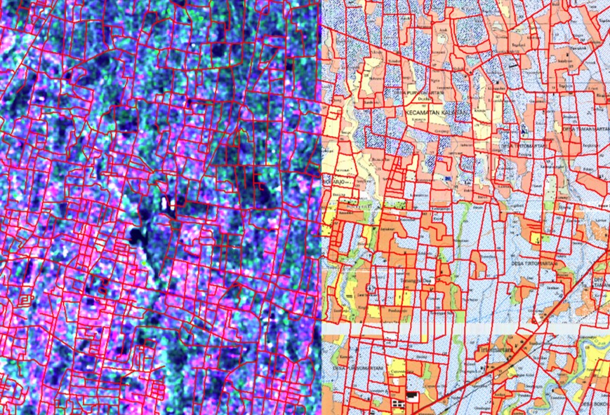
We process from image to information by using digital interpretation. This use some recent digital classification and DEM extraction technique, such as Machine Learning; Object Oriented; standard Area-Based; Interferometry SAR Interpretation. We Also produce GDEM+ (Global Digital Elevation Model) from Interferometry SAR Imagery
Our Partner

Reseller Product